

Rapid moves… Is Saudi Arabia moving towards swallowing up the border areas in eastern Yemen?
SANAA, Feb. 17 (YPA) – Talks of Saudi endeavors to swallow Yemen’s eastern border strip are no longer merely analyses or speculations.
Instead—according to field data and official decisions—they have become clear indicators of an organized trend to redraw the geographical and sovereign reality in the oil-rich desert regions extending along the border strip of the Hadramout and Mahra governorates, which are under Saudi control.
The Geological Memorandum of Understanding
Middle of last week, the Saudi Council of Ministers announced the authorization of the Minister of Industry and Mineral Resources to discuss a draft Memorandum of Understanding (MoU) in the geological field with the “government” of Rashad Al-Alimi.
Although the agreement appears on the surface to be “cooperation,” observers confirm that the geological agreement is nothing more than a cover for broader field movements, especially given the total lack of transparency regarding the nature of the studies or their geographical scope. Observers suggest that Yemen’s border areas are among the primary targets of this agreement, as these regions are the richest in minerals in Yemen, in addition to the oil wealth they contain.
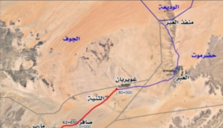
Saudi Movements in Al-Abar
The Memorandum of Understanding coincides with notable field movements in the Al-Abar district of Hadramout Governorate, which is one of the largest desert districts, spanning an area of approximately 8,000 square kilometers.
Media outlets have reported on Saudi efforts to move the Al-Wadeeah border crossing to an advanced position inside Al-Abar, reaching a depth of about 50 kilometers inside Yemeni territory. This follows the announcement by pro-Riyadh factions of tightening control over Al-Abar and converting it into a military operations zone, along with the deployment of formations known as “Emergency Forces” with Saudi support, which reinforces this hypothesis.
What is happening in Al-Abar is interpreted as an extension of what is occurring in the Al-Kharkhir desert area on the edge of the Empty Quarter, where Saudi Arabia is working—simultaneously with military movements—to erase the Yemeni identity of this region.
According to media reports, Saudi Arabia officially requested Google in late January to remove the Yemeni villages of Al-Kharkhir from its maps. The company complied, and it was noted that the name of the region and several of its villages disappeared from the maps, coinciding with military movements on the ground.
The overall indicators—from the geological MoU to the repositioning of the border crossing, as well as the military movements and mapping changes—paint a scene suggesting a Saudi attempt to swallow the Yemeni regions located behind the border strip of the Hadramout and Mahra governorates in eastern Yemen and impose a new geographical reality.
YPA